Sunday, January 15, 2012
Planning My Annual Run
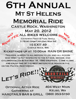
The time has come to start organizing the run I lead every year. I do it for personal reasons, since I was suppose to be at Mt St Helens with my Dad when it blew. But by fate, the weekend I was suppose to take Dad down to relieve another Ham radio operator at an observation post was Armed Forces Weekend. The ship I was stationed aboard was visit ship in Seattle that weekend, and I had to be there. When I told Dad I couldnt take him down that weekend, but I had all the next weekend off, he got in touch with his friend Gerry and rescheduled. I was aboard ship in Seattle when I heard the word that the mountain blew. My Dad's friend Gerry was one of the 57 killed in the blast. His body, hell, his entire campsite and RV were never found.
It took me nearly 20 years to bring myself to go back, to the area of Coldwater Ridge where we were supposed to have been that sunday morning. Now, I lead a ride all the way to Johnstons Ridge, every year in the memory of the 57 men women and children who were killed that morning.
I have to admit, making this run on one of the best motorcycle roads in the state doesnt hurt any. It has grown every year since I started this run. The first year, it was a friend of mine from Astoria, Oregon and me meeting up in Castle Rock, Washington and making the ride. By the 4th year, we had over 40 bikes, and a couple of cars along. Last year, the weather was horrible. Record rain amounts had come down in the hours leading up to the start, and it was still dumping down. The temperatures were in the mid 40s, and by the time we stopped, at one of the visitor centers and were told it was snowing just a couple miles ahead (with 15 more miles to go, and 1,500 feet more elevation to make) I had everyone turn back. At that point it was 39 degrees, and we had a 15F degree windchill. Even with the weather like it was, we still had over 30 bikes show up from Oregon and Washington.
Last year, I started an after run gathering at a biker bar in Kelso, which worked out quite nicely. The place is called Hardtails Bar & Grill, and is fairly large, and has great food. A few pool tables, and good drinks dont hurt either.
The run starts at a Shell Station (with a LARGE parking lot) just off I-5 at exit 49. That makes it very easy for everyone to find the start, and get topped off with gas. It is about a 105 mile round trip, but there are no gas stations past the 20 mile point. The road itself starts from only about 200 feet or so above sea level, and winds up to 3,500 feeet before dropping down to 1,800 ft. Then climbs back up to 4,300 feet at the end. Climbing from riverside forests, and up into the sill devasted blast area of the volcanic national monument. There is even a sign along the road about 10 miles from the monuments boundary that says "ENTERING BLAST ZONE". All the trees between here and the monuments boundary were replanted after the 1980 eruption. The mud and debris flow can be seen in the valley floor, where the old road went. It is now under 100 feet of rock and mud. Nearly to the mountain it is more than 200 feet under the surface.
If you are in the area of SW Washington come May 20th I would love to have you come along and enjoy the ride. There is no ride fee, and it doesnt matter what you ride. Just as long as you are willing and open to be amazed at the awesome power of nature displayed along this ride.
If you cant be in this neck of the woods at that time, but EVER find yourself on I-5 near exit 49 with a few hours to kill. take the exit, and head east to the end of the road. It will be worth it...if not for the sake or this wonderfully ridable road...but for your own piece of mind.
Catch ya on the road sometime...
Subscribe to:
Post Comments (Atom)


No comments:
Post a Comment