
The Road To Paradise
(A Ride Through Mt Rainier National Park)
This ride begins in the small lakeside town of Elbe, Washington. At the eastern end of Alder Lake, at the junction of WA-7 and WA-706. On a nice summer day, Elbe is a good place to start a trip like this. With steam train rides, an historic little Lutheran church, a restaurant made from railroad cars, and even a motel made from cabooses, Elbe is a prime example of a small picturesque community clinging to its history to draw in the passing tourists. Gas and supplies are available, and food service ranges from; an Espresso stand through a small hamburger stand at the old log scalers shack, to a bar and grill, to a full service restaurant and lounge at the Mt Rainier Scenic Dining Company.
This is, depending if you ride to Paradise or bypass it through the park, approximately a 50 mile ride. However, once you reach the junction with US-123(WA-123 as it passes through the National Park) you will have to choose one of three options:
1) Turn south (right) where your nearest fuel is in Packwood only 13 miles away.
2) Turn north (left) where your nearest fuel is in Greenwater another 32 miles away.
3) Turn around, and ride back to Elbe.
I would actually suggest, depending on your final destination, the third option. As riding from east to west gives an entirely different perspective to the ride. For a good portion of it riding up from the east you are facing Mt Rainier, and it makes for an impressive ride.

Starting at the junction of WA-7 and WA-706, simply head east on WA-706 and you are on the road. The road from here to the park entrance is mostly straight with only a couple of mild curves that barely ease the sameness of this part of the ride. Even though riding through the Nisqually River valley is quite scenic, it is nothing compared to what lies ahead. However, that all changes, almost immediately after entering Mt Rainier National Park.

Only about 2 or 3 miles outside of Elbe, on the right hand side, you will come to a piece of property filled with metal sculptures. It is a nice little roadside attraction and there is a small “donation” to wander through the entire exhibits. But it is well worth it. The last time I was there, the band seemed a bit stiff, and rusty, but it was still very much a pleasant time at the beginning of the ride.

 When you arrive in Ashford, there is another opportunity to top off your tanks before entering the park. If it is a bright sunny, or bright overcast day, I would suggest picking up some sunscreen for the ride. Also, don’t be surprised by how much the temperature drops in the rise from the 1200 foot elevation of the valley floor to the over 5,000 foot elevation of Paradise. Have an extra layer of two handy. Even on very hot days. A 20 degree or more difference is not unusual during this ride, and Mt Rainier does create her own weather at times, so be prepared for it to change on you without a great deal of warning. Between Ashford and the park entrance, the forest tends to close in a bit more on the road, and the curves begin to show just a hint of what lays beyond the gateway into the National Park itself. To some, it is a bit of a shock, because after you cross under the gateway, development stops until you reach Longmire.

Shortly after passing Longmire, the road begins to show its more curvaceous nature. From this point on, except for campgrounds, and viewpoints there isnt much in the way of developed spaces until you reach Paradise. But as you can see by the map, the turns begin to tighten, and curve back onto themselves continuing smoothly up the slope of the Nisqually River valley. A fairly tight left hand turn after Cougar Rock Campground leads into a short straight before the road begins another series of turns through the forest, with occasional openings for views of the ridges and the river itself.
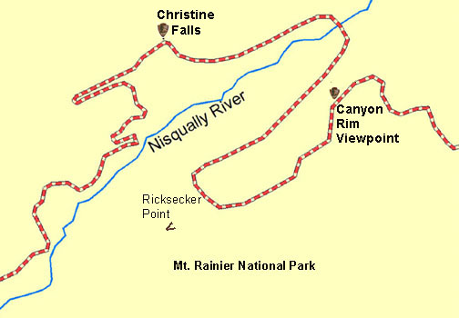
As the road moves out into the middle of the valley floor you come to a pair of hairpin curves that first brings you back towards the southwest before pulling you right back the the northeast. Then it begins to climb back to the ridges base in a series of gentle sweepers with a nice hairpin in the middle. As the road reaches the base of the ridge, there is a left handed sweeper leading to a nice straight. At the end of the straight the road makes a tight right hand hairpin and climbs upward along the ridge. What follows is a fairly straight climb, with only a bit of a left hand curve in the middle until you reach Christine Falls. There is a small pull off just before the bridge at the falls. But a better view of the falls lies just beyond the tight right turn immediately following the bridge. There is a much better place to park and a short path that takes you to a lovely view of the falls. From here the road follows a much more broader climbing left turn up the ridge before straightening again just before Nahunta Falls. Once the road passes Nahunta Falls it turns to the right and crosses the bridge over the Nisqually River before taking another sharp right and beginning the long steep climb diagonally up along the canyon wall. Where the road takes a pair of big sweeping left turns as the road levels of somewhat but still climbs. Giving excellent views across the Paradise River Valley of both Eagle and Chutla Peaks. Before gently following the ridgeline passed the Canyon Rim Viewpoint, and an excellent view of Mt Rainier. From there the road climbs again, first in a long sweeping right hand turn, then a straight before swinging tightly left and then another right sweeper. Then another straight before rounding to the left once more climbs up towards Narada Falls.

I heartily suggest not only stopping here and enjoying the view from the top of the falls, but if at all possible take the short walk of a couple hundred yards down the path and view the falls from below and across the narrow canyon end. This is a wonderful spot to take a break, and stretch your legs on the way up to Paradise.


After enjoying your visit to Paradise you can head east past Reflection Lake and Louise Lake before beginning your descent into Stevens Canyon, and finally reaching the north south road at the east side of the Park (US123) or head back west the way you came and enjoy the same road, but from a totally different perspective. That is the sweet thing about the 'Road To Paradise', no matter how many times you ride it, there is always something you never noticed before. Even if you were just on it 30 minutes before. So get on it and enjoy yourself. See the sights, and the animals, and let yourself enjoy the climbing twisting path that the road takes you to as you climb up to Paradise...and maybe beyond?
Catch you on the road sometime...
No comments:
Post a Comment